SLGT risk of Severe Weather today/3-18...Extreme heat continues across much of the USA...Snowy in the Southwest

Minimal chances of Severe Weather today and tomorrow

Low chances for Severe Weather exist today through the end of the week as several weak impulses move across the United States and out to sea. The first threat of strong to severe thunderstorms will come this afternoon across portions of the Mid-Atlantic. Current temperatures across the threat area reside in the mid-50s,  but are expected to soar into the low-70s by the afternoon. Modest dew points in the 50s will likely rise to AOA 60 °F, paving the way for convective activity. The two main limiting factors for today, however, are a lack of low-level convergence and forcing. Due to this reason, only marginally severe hail and localized damaging wind gusts will be expected. This activity will rapidly diminish after sunset.

As a weak shortwave moves into the Central Plains tomorrow, it will be met with an increasingly favorable region for severe thunderstorms.  Peak heating should add additional energy for storms to fire off of, and steep mid-level/low-level lapse rates should encourage a hail/damaging wind threat. However, due to relatively weak wind shear, the threat of tornadoes is low. While it is not entirely clear where the main focus of convective activity will evolve, current thinking is that storms will fire across the Texas/Oklahoma Panhandle and Kansas in the evening, spreading across Iowa, Nebraska, and into the Great Lakes region as a low-level jet helps promote nocturnal activity, with a continued threat of hail and damaging winds.

Storm Prediction Center Day 2 Probabilistic Outlook

Strong to severe thunderstorms likely today

The Storm Prediction Center has issued a Slight risk of Severe Weather today over parts of lower Michigan and surrounding areas, and then farther south across portions of Mississippi, Alabama, and Tennessee. as a weakening upper-level low moves across Lake Superior and into Canada this afternoon. At this time, isolated strong thunderstorms exist across south-central Louisiana, and farther east across the Florida Panhandle as a weak boundary and associated upper impulse moves across the Gulf of Mexico. These storms occasionally exhibit weak rotation, but insufficient parameters will prevent a high tornado threat. Regardless, isolated brief/weak tornadoes are possible, along with damaging wind gusts. Mesoscale Discussion #247 states that a weather watch is not likely across this area, but convective trend will be monitored.

Current radar imagery across Louisiana and the Florida Panhandle
The main threat for Severe Thunderstorms will arrive this afternoon as daytime heating, combined with maximum forcing come together. Storm Prediction Center Mesoscale Analysis reveals approximately 100 j/kg of MUCAPE along with Effective Bulk Shear near 30 kts associated with an intensifying line of thundershowers across northern Illinois. As the weakening upper-level low moves northeastward, expect this line to progress east and east-northeast with the possibility of producing damaging winds and an isolated tornado. As we head into this afternoon, expect isolated supercells to fire across northern Indiana and lower Michigan. The threat will end later on tonight as main forcing moves away.

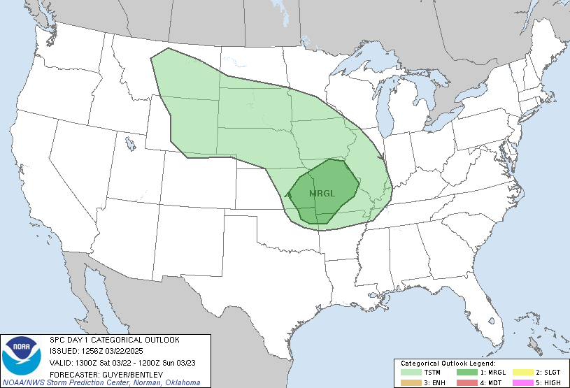
Storm Prediction Center Day 1 Categorical Outlook

Spotty Severe Weather tonight and tomorrow

Spotty Severe Weather seems likely overnight and into tomorrow as a potent upper level low moves across Iowa, Minnesota, and Michigan tomorrow. At this time, a batch of heavy rainfall with occasional embedded severe thunderstorms is moving across southeastern Arkansas and eastern Louisiana, where Tornado Watch #72 is in effect until 200 AM CDT. While isolated spin-up tornadoes, large hail, and damaging wind gusts are possible, especially due to strong wind shear and favorable wind profiles across the region, instability seems too meager to support a more significant threat of severe thunderstorms. As the night progresses, expect this line of storms to gradually die out.

For the day tomorrow, the Storm Prediction Center (SPC) has issued a Slight risk of Severe Weather across northeastern Illinois into much of lower Michigan. As daytime heating occurs across this area, expect little in the way of convective inhibition by the afternoon hours. Despite model differences between the GFS and NAM, strong forcing ahead of a trailing cold front should allow for severe thunderstorms capable of producing large hail, damaging wind gusts, and isolated tornadoes. Farther to the south across Kentucky, Tennessee, Alabama, and Mississippi, convective initiation ahead of a stalling cold front may occur. However, due to dry air and lack of significant forcing, the main threat will likely be large hail.

Storm Prediction Center Day 2 Probabilistic Outlook